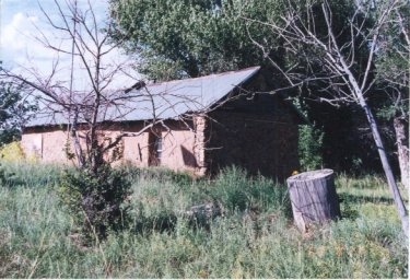
Pictured above is an old adobe Bonney abode, built in the 1800s, as it now looks at the beginning of the new millennium. It is on private property located in northeastern New Mexico. The Bonney who built it and lived there was — like my mother’s great-half-uncle, Ramon Bonney — the son of a blue-eyed Englishman named James Bonney.
I had no interest in him, I preferred reading Gothics instead.
Although I live near Lincoln, I never gave him much thought;
epic and mystery were my choices, cowboy shoot-em-ups were not.
Now, stories that I really loved were ones my mama would tell
of her intriguing family history, ah those tales she told so well!
My mama, born in ’09, had an uncle of whom she spoke.
(The uncle babysat her when he was an aged cowpoke,
that bewhiskered old man had held her when she began to cry.)
Ramon Bonney was his name, and he lived in a cabin nearby.
His place was in a desolate spot on the picturesque canyon rim
over-looking the Yegua; it was a lonesome place for him.
excerpt from A Bonney Ballad
Rwm
Ramon was a contemporary of Billy the Kid and he went to Las Vegas, NM to visit Billy when he learned he was incarcerated there, to see if they were related. A historian, whose practice it was to do his own research by interviewing old-timers and looking for original documents and court records, believed there was a strong possibility the two Bonneys, Ramon and Billy, were related. (And therefore also, related to the original occupant of the pictured dwelling.)
The origins and genealogy of Billy “The Kid” Bonney and his early life remain a mystery. So too is the mystery of why he, in the latter portion of his short life, adopted the name Bonney. Most published historians believe that: a.) He began life in New York as Henry McCarty; b.) He changed his name to William Henry Antrim to match his stepfather’s after his mother’s marriage in Santa Fe in 1873; and c.) He adopted the name William H. or Billy Bonney only in the last few years of his life. Historians don’t seem to know from where he acquired or why he adopted the Bonney name. Most admit they are uncertain, but think he might have been born in a New York City Irish slum in 1859. Both the place and the date of his birth could well be incorrect.
Rwm

For years, a friend suggested we drive up State Road 3 from Duran to I-25. We always seem to leave home just in time to arrive in Santa Fe for a meeting, so adding a side excursion was never on the agenda. Finally, we did plan the trip from southeastern New Mexico up State Road 3, with its historic old churches, buildings and scenic surroundings, to I-25 and then to Santa Fe.
State Road 3 begins, or ends, depending upon your perspective, in Duran. It is a two-lane road that heads roughly north to Encino and thence to I-40. After crossing I-40, it continues north until it falls off into the Pecos Valley and winds through Villanueva, Sena, Pueblo, San Miguel and Ribera before ending at I-25 about 25 miles southwest of Las Vegas, New Mexico. There, State Road 3 merges with I-25 to Las Vegas and then separates again at Las Vegas and continues north to Mora, and ends at Talpa just south of Taos.
The historic part of the trip we took is between Duran and where it merges with I-25 SW of Las Vegas. For Interstate travelers, a shorter trip could begin on I-25 with a short 15-mile drive south beside the Pecos River, through Ribera, San Miguel, Pueblo, Sena and end at Villanueva and Villanueva State Park.
We began our odyssey by leaving US-285 at the junction three miles west of the old railroad town of Vaughan and continued southwest on US-54 for twelve miles to Duran.
Take the journey with us. Be prepared to take photos in Duran. Take time to drive around viewing the deserted school and fire station, a church and a few homes and businesses.
After your photo-op in Duran, cross US-54 and head north on SR-3. You will notice Duran is surrounded by a forest of small evergreens. They appear suddenly as if planted on purpose about 10 miles east on US-54 and disappear about 10 miles north on SR-3. The road north to Encino has a few curves, but is relatively straight. It passes a group of salt lakes that are dry most of the year.
North of Encino, SR-3 is straight for some miles, passing through the Perez Ranch. The view in the rear- view mirror is a long ribbon of blacktop as far as the eye can see. Along the way are deserted stone houses with dark, paneless windows and gaping doorways.
After about 45 miles, there is a sudden change. Curves develop and the road drops into the valley of the historic Pecos River.
A BMW flashes past going in the other direction, top down, a permanent smile on the occupants’ faces as the driver stirs the transmission through the gears. The exhaust note bounces off the red hills on our side of the road, then it is gone around another corner. Combined with the vistas that lay around you, behind you and before you, the fact that this is also sports car country seems to be a paradox.
Cross a bridge and you are in Villanueva, or La Questa as it was originally named. It sits above the Pecos River, surrounded by mesas that form the valley. Villanueva is made up of three small plazas, Llano, Wauche and La Loma; all are within walking distance of each other.
Villanueva (pronounced VEE ya new A vah) means new village, but it looks mighty old. Villanueva is the focus of State Road 3 and you will want to linger. Bring lots of film. You feel as though you fell into a time warp 200 years back.
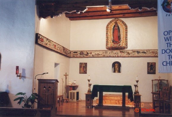
The two-centuries-old church in Villanueva, Nuestra Senora de Guadalupe, houses a unique celebration of our nation’s Bicentennial. Village women recorded the history of the area on a 265-foot tapestry that hangs on the inside walls of the church, surrounding the sanctuary. The tapestry was completed and dedicated in the summer of 1976. (pictured below)

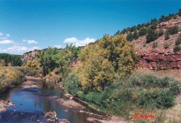
On the twelve-mile drive from Villanueva to the Interstate you continue your time-machine journey into the past. SR-3 curves through a tunnel of aged cottonwood trees on the river side and red cliffs on the other side. Abandoned adobe houses and businesses, once built to withstand Indian raids, wink at the passersby with sightless window eyes. You pass hay fields, farm houses, and acequia (irrigation ditch) as you visit Sena, Pueblo and San Miguel.
Historic San Miguel has its church in the center of town. A way-stop on the Santa Fe Trail, it is one of New Mexico’s oldest towns. Some say the town was founded by Indians who became Catholics. When Nuevo Mejico was part of Mexico, San Miguel was the seat of the Catholic clergy. There is a legend that the town’s early rich are buried beneath the floor of the church.
This is also where the men of the ill-fated “Texas Expedition” rested after a harsh march on the way to Mexico. As the Texans lingered across from the church at the southeast corner of the old plaza, some of Gov. Armijo’s men shot some of them. The executions were stopped by Gregorio Vigil, a prominent resident who refused to allow more Texans to be killed.
A few miles beyond San Miguel is the picturesque town of Ribera, nestled among the trees. It has many interesting old adobe structures.
The southern part of State Road-3 provides a refreshing change from cruising up the new four-lane highway from Roswell to I-40. Depending upon the length of your stops and how many you make, the side-trip could only take a half hour or so longer than usual, but you will fall onto a a colorful tapestry depicting early New Mexico.
To further enhance your enjoyment of the journey, take the drive in October when the trees are in their fall splendor.
 Roswell Web Magazine