(The following two articles — written by Morgan Nelson and Bernice D’Abadie, the area’s leading water historians — provide history of some, but not all, of the earliest known ditches in the Roswell Basin of the Pecos Valley. Refer to maps on the Home page of this issue for locations of some of these ditches. The photos labeled HCSNM are from the archives of the Historical Society of Southeast New Mexico, which was previously called the Historical Center for Southeast New Mexico. These photos were made available to Rwm to accompany these articles by the Society’s archivist, Elvis E. Fleming.)
In the early days, there were four streams flowing from large springs in the vicinity of what is now known as Roswell. They were large clear rivers teeming with fish of all sorts, including eels. In 1866, when surveyor Hiram C. Fellows ran the first survey line on the second parallel south on what is now known as Second Street, he reported three irrigation ditches that crossed what was to become Main Street. They ran from the North Spring River watering considerable land under cultivation along the Hondo. (Shinkle, Klasner, Prager)
The South Springs River was a large stream fed from springs rising in the endless prairies west of the Pecos. To the east of the Pecos were the red bluffs. There were no trees, shrubs or brush in the area except for a few that survived close to the water’s edge. Frequent prairie fires, set by lightning, swept over the plains, purging all trees and shrubs, leaving the land surrounding the springs pure grassland. These springs were located in the area now known as South Springs Acres Subdivision, about four miles southeast of Roswell.
The earliest ditches in the area that we can identify were probably at Missouri Plaza/Bottom, 15 miles southwest of Roswell. When the Robert Casey family arrived there in 1867, they reported “very fertile soil accounted for the existence of Missouri Bottom. In those days the Hondo was a good-sized stream so full of water that it ran almost to the top of the banks. This made irrigation easy, and the crops grown in the fields surrounding Missouri Bottom were as good as you wish.” (Shinkle)
The first known settlers on South Springs River in the 1860s were an old German named Isenstein and his wife. They lived in a dugout overlooking the springs. For many years, the springs were known as El Ojo del Aleman, or Spring of the Dutchman. (Klassner) What happened to him, we don’t know.
By 1872, a Mexican family, headed by Pedro Sanchez, claimed the headwaters of the South Springs River and the land surrounding it. He owed $3,000 to a cattle trader named James D. Patterson. Patterson was the first person to erect a building in what is now Roswell. He sold his interest to Van Smith in 1870. Patterson got the Sanchez land for the debt owed him. In 1894, he traded South Springs to John Chisum for a $7,000 debt he owed Chisum. (Notes from Roswell Daily Record, Klasner, Shinkle.) By 1874, Chisum began moving his headquarters from Bosque Grande to South Springs, where he had a store. His house was the old block fortress-like house of Pedro Sanchez.
Whether or not Sanchez had started a ditch, we have no record, but he probably did. Chisum seemed to prefer farming to ranching. (Klasner) When his cowboys had nothing else to do, he had them digging ditches. They hated it. When Jim Miller saw Chisum in 1878, he was raking alfalfa that he had cut near his house.
There were actually three Chisum ditches– the Chisum Dam diverted water from South Spring River and became the North Branch and the South Branch. The third ditch, the Chisum Highline Ditch, was fed from a separate spring and generally paralleled the Old Dexter Highway and the present railroad track. It ran under John Chisum’s new house. The Chisum ditches watered the west and central areas of East Grand Plains. (Klasner)
Above the Chisum Dam was the Woodlawn Dam that held the springs that fed the entire system.
Chisum intended to keep all homesteaders out of the area, but they began pouring in and he could not stop them. He bargained with newcomers, the Corn family, to settle on the north side of the South Springs River, and he would keep the south side and the extended prairie to the south for himself. (Miller & Dills) The Woodlawn Ditch was first mentioned in 1872. (page 253, Hordes) With the Pumpkin Row Ditch, first mentioned in 1877, along with the settlement there on the north side of South Springs, little could Chisum do but acquiesce to this arrangement. (Miller)
After J.J. Hagerman acquired the Chisum properties, he subdivided and sold off much of the land, along with water rights from the Chisum ditches. Beginning after artesian wells were drilled, the flow of the springs began to diminish and Hagerman was not getting enough water to meet his obligations. One night, he got a crew of men together and dug a channel through the Woodlawn Dam and drained the water into his dam. A group with Woodlawn Ditch water rights sued him, resulting in the adjudication of all the surface rights of the South Springs River. It was a bitter, long litigation and by the time it was finally settled, most of those concerned had their own artesian wells and it was no longer as important. (Final Decree in Chaves County, Civil District Court No. 433.Woodlawn ditch Company v. South Springs Land and Cattle Company.)
Sally Chisum testified that when she arrived late in 1877, the grass caught in the stirrups of their saddles as they rode across the prairie. Sally said the Jake Harris Ditch was already dug, used and abandoned two years before she had arrived. (Testimony, Chaves County Civil District Court No. 433) Jake Harris was one of the Mormons who settled in the area of where the Oasis Ranch is today. The ditch came out of the South Springs below the Texas Ditch Dam and ran southeasterly to just west of the Whitney places. It was abandoned in about 1876 because it ran through gyp hills and would not hold water. All of the Mormons, except Jake Harris, left the country because factions in the Lincoln County War intimidated them. Jake Harris stayed at his place, which was west of the others’. He was a good, close friend of John Chisum. A remnant of this ditch may still exist.
Late in 1879, Jim Miller took over and enlarged the ditches abandoned by the Mormons who fled the year before rather than be forced into the Lincoln County War. This ditch was taken from the south bank of the South Springs about 400 yards below the “natural bridge.” For many years, it watered what is now the Oasis Ranch, and when there were sufficient artesian wells to water the ranch, he sold the water to the Hagerman Canal. Since this ditch was at the lower end of South Springs, it still has water and flows even today, because about 3/4-mile of this ditch still exists.
The Woodlawn Ditch went north and received its water from the first dam on the South Springs. The main large spring, the headwaters of the South Spring River, was at the western end of the river. The first mention of this ditch was in 1872. The Woodlawn Dam may have been the first on the river because it seems doubtful that anyone would let someone build a dam above him. An agreement was reached to allow enough water from the South Springs to flow over and through the Woodlawn Dam to service the other dams, but to not affect the prior appropriation of ditch rights. There was just too much water for them to use.
This ditch ran to the north generally paralleling, and east of, the railroad tracks. It carried water to Second Street and irrigated the land west of the Pumpkin Row Ditch. all went well until the artesian wells lowered the water pressure and the springs’ water began to diminish. This was when Mr. Hagerman took direct action and dug a channel around the dam. By the time the lawsuit was settled, these farmers had replaced their surface right with underground water. This happened about 1897 and the suit settled in about 1904. (I am vague about these dates as I don’t have the records before me.)
A Mexican settlement was on the north bank of the river known as Pumpkin Row. (Klasner) It is also known as Ditch Number One. Pumpkin Row seemed to be a shady place. Apparently there was a bar there, because it had the reputation for drunks and fights. This ditch ran due north and the present road named Lipan was on the upper side of it. (Klasner, Hudson)
The Corns, with their caravan of Texans, arrived in 1878 and settled in what is known as the LFD area. They agreed with Chisum to settle on the north bank of the South Springs and leave the south side for Chisum. The river, though clear, had treacherous bogs on either side and divided the two communities of LFD on the north side of the river and East Grand Plains on the south side of it. With the exception of one dangerous crossing, the communities were effectively divided. The Corns started this ditch in 1878 and irrigated the land east of the present White Mill Road. Martin Van Buren Corn installed a gristmill at the mouth of the Spring River. It operated until the Blashek family built one near Roswell on North Spring River.
Well owners on the Berrendo River were the first to receive vital notice from the State Engineer that they may claim an earlier water right priority date if their land was irrigated by one of the area’s major irrigation ditches in the 1880s to 1905, before artesian wells were drilled.
A meeting to which all other well owners were also invited by legal advertisement was held March 20. State Engineer’s staff were available to explain the Templeton Doctrine, the process of relating water rights back to the use of irrigation by ditches taken out of the four major rivers in the Roswell area.
By 1905, it has been creditably estimated that 10,000 acres of land in the Roswell area were irrigated from ditches taken out of the Berrendos (Middle, North and South), the North Spring River, the Rio Hondo and the South Spring River. Early priority dates give the well owners a tremendous advantage in times of drought and water shortage on the Pecos River, but the relation back to irrigation by the early ditches must be reasonably proved.
Morgan Nelson led with an article on ditches in the southeast area. This article will focus on the major early ditches in the northeast area of Roswell. The State Engineer will allow claims relating back to early ditch use on a ditch-by-ditch basis over the coming months. The process will start with the ditches farthest north and work southward.
The four Milne-Bush ditches, the first ditches in the area, were taken out of the Middle Berrendo and the South Berrendo Rivers in 1885-1887. At one time, the Milne-Bush Ranch covered 3,400 acres, of which 1,000 acres were irrigated. Much of the land is within Roswell City limits now and not used for farming. The Milne-Bush Cattle Company was bought by the Berrendo Irrigated Farms Company and sold in smaller parcels with a right to use water from various Milne-Bush ditches. Those deeds are important documents when they show specific lands irrigated, even within city limits, because today’s lawns, gardens and shrubs qualify as beneficial use of water, just as farm crops did long ago. This may be of help to the City of Roswell in claiming an earlier water right date.
Over the years, all that remains of the Milne-Bush Cattle Company is the ranch house on the South Berrendo River. At one time, Edward Nicholas, a noted author, scholar and businessman lived there and added onto the original house. Carolyn Schlicher, daughter of Charles Lovelace, presently owns the house and grounds.
Lucius Dills, an early Roswell newspaper editor, credits the Sedillo family and about nine other Spanish-speaking families for being the first settlers in the Roswell area who stayed and hand-dug the Sedillo Ditch out of the Middle Berrendo River starting in 1879. The settlement was the first to start a ditch for irrigation, but the settlers were run out by Texas outlaws who raided the settlement, stole or destroyed everything including the women’s shawls. The Texans told the people to get out and not come back. Thinking the outlaws were part of the hated Horrell family from Texas, most settlers left. Cosme Sedillo stayed and has been noted as one of the 100 men who helped develop Roswell.
Some other families who stayed on the Berrendo were the Fresques, Sanchez, Somoros and Chavez. The Sedillo Ditch irrigated several small farms. Traces of the ditch can still be seen just west of Calumet Drive. Frank Sedillo, who lived on the home place, said his grandfather sold the land which is now owned by the Roswell Country Club. Frank Sedillo died in 1994.
Harry Leonard, a popular independent oil man who lived north of the Roswell Country Club in the 1930s-1940s, claimed water rights from the Sedillo Ditch for 23 acres of bottomland south and east of the AT&SF Railroad. The Steins bought and maintained the Leonard place since that time.
The longest ditch to be taken out of the South Berrendo River was dug by Richard F. Barnett, Liberty Walters and Jack and James Rowden in 1888. The Last Chance Ditch began shortly down-river from where E. Berrendo Road dips into the riverbed. The ditch, taken from the north bank, was 16 inches deep and 10 feet wide. It ran due east for four miles. An early deed showed water from the ditch was used to irrigate 640 acres.
The Charles DeBremond Farm used water for 400 acres from this ditch. Known widely for his leadership of the Battery A during World War I in France and during the chase after Pancho Villa, Col. Charles DeBremond owned a large farm and vineyard east of Roswell which he managed in a progressive way. The DeBremond farm was also irrigated with water from other ditches not featured in this article. A drive down the gentle curves of Zinnia Road, east of Roswell, follows the course of the Last Chance Ditch.
Pat Garrett, the legendary sheriff of Lincoln County, was an early developer of irrigation projects in the Pecos Valley. When the words “Garrett’s Dam” are mentioned, they could refer to more than one dam. At the eastern end of E. 19th Street, a private dirt farm road intercepts the south Berrendo River farther to the east. This was the location of Garrod’s Dam, which many associate with Pat Garrett because he and William Crow put in an excellent dam and diversion ditch in 1882. At a later time, the Garrod family owned the farm that gave the dam its common name. The small reservoir behind the dam was the favorite swimming hole in the Roswell area in early years because it had a gently sloping gravel bottom. The Crow Ditch, about 8 feet wide, was a shorter ditch that irrigated over a hundred acres of land, including part of the Charles DeBremond Farm.
The North Spring River, which began as powerful springs in the present Enchanted Hills area of Roswell, furnished a steady flow of water for the Stone Ditch, starting at the municipal golf course and heading northeast to the Roswell Country Club area. Riverside Drive ran along the side of the ditch. A short trestle bridge, just northeast of the railroad intersection with E. College Blvd., marks the spot where the Stone Ditch left the city and headed northeast to the large Stone Farm. Credited by some as the first man to grow alfalfa in this area, Judge Edmund T. Stone and his teenage sons, John and Price, dammed North Spring River with stones and developed the long ditch in 1883. James D. Shinkle, a noted Roswell historian, wrote that at one time Judge Stone and his son, John, owned all the land between the South Berrendo and North Spring rivers from the front of the Country Club to where the Berrendo joins the Hondo River to the east. That could be over 1,000 acres.
John Stone, after his father’s death, sold 640 acres to J.J. Hagerman, who turned the land into the Fairview Subdivision. According to Carroll White, a former superintendent of county schools now living in a local retirement home, Hagerman incorporated the Roswell Land and Water Company. Its purpose was to sell the land as 10-acre truck farms, with each having a 64th share in water from the Stone Ditch. Fairview still exists as small holdings between E. Nineteenth Street and E. College Blvd., east of Atkinson Ave. John Stone held back one-half of the water in the ditch for his own farming. Most of the deeds for land in the Country Club area still show water rights out of the Stone Ditch.
The City of Roswell holds the major interest in claiming early ditch rights in the Blasek Ditch. The Charles Lovelace Park, near the intersection of N. Atkinson Ave. and E. College Blvd., was the location of the Blasek home, grist mill and ice plant. George Blasek filed a ditch right in 1887, declaring that the Roswell Mill Ditch took a good supply of water out of the North Spring River east of the railroad bridge, and ran east to his mill for milling, manufacturing and agricultural purposes. A portion of that cement lined ditch still exists near the Recreational Trail west of the Loveless Park.
Nearby, the Pioneer Ditch was taken out of North Spring River in 1881 at a bend near Roswell Livestock Auction Company. The river has been straightened, but the original bend is still visible. The ditch ran south and east, crossing Atkinson Ave., then Hondo River that it crossed by flume. Water was picked up from the Hondo River, and one branch of the ditch ran east through the large C.C. Slaughter Hereford Farms to an area near the former saline water plant on E. Second Street near the Pecos River. The Slaughter estate estimated that 844 acres were under cultivation from the Pioneer Ditch.
Frank C. Miller, a former assistant district attorney in Roswell, now a resident at a local retirement home, remembers talking with Percy FitzGerald in the1950s. Percy stated that the FitzGerald farm near the saline plant received irrigation water from the Pioneer Ditch in earlier years also. Other acreages were irrigated from the Pioneer Ditch, which branched and carried water into the southeast area. Traces of the Pioneer Ditch still exist on a few farms along the north side of E. Second Street.
This short summary of early irrigation ditches in the Roswell area does not include all the ditches that were used in the development of agriculture before artesian wells were drilled.
Landowners who wish to file claim to early ditch water rights for the advantage of an early priority date are strongly encouraged to attend the State Engineer informational meetings. Even those who have filed claims earlier need to know what sources of proof are available. Those who have never filed claims are allowed by Judge Harl Byrd, presiding over the long, drawn-out L.T. Lewis case, to come forward now. It is hoped that many water rights in this area will be given the earlier priority dates they deserve.
Some people are told, tongue in cheek, that they are one in a million. Bobby Corn was told he really was one in 21,000; now that was a big deal. After much screening and red tape, only one out of every 21,000 was the ratio of people accepted from the vast number of those who applied as volunteers to work at the 2002 Winter Olympics.
Corn — also known in Roswell and throughout the state’s judicial system as Magistrate Judge Robert B. Corn — had given up hope of going to the 2002 Winter Olympics in Salt Lake City, Utah and began to make other vacation plans.
January 24th, prior to flying to Santa Fe on important New Mexico legislative business, he had received an offer, by Email, from the Salt Lake Olympic Organizing Committee, and responded, accepting the offer. On Jan. 25, after returning from Santa Fe, he saw his acceptance from the Committee selecting him as a volunteer for the Olympic and Paralympic Winter Games of 2002.
He was chosen for the position of Athlete Driver.
His Email told him and 90 other selected Athlete Drivers that they would be responsible for ensuring that the athletes arrive at their competitions safely and on time. The position involved the operation of a new, fully-insured GMC 15-passenger van. The vans were provided by General Motors and gas by the sponsorship of Texaco. He fit the applicant requirements, including having a valid driver’s license and no traffic points, and much more, including having a valid commercial driver’s license. The Email said drivers would be provided thorough training, but knowledge of local roadways would be helpful. Corn had never before been in the Salt Lake City area, but he was ready to learn.
The Committee wanted him available for dress rehearsals and special events before the Olympics officially began.
There was one small problem. They wanted him in Salt Lake City by the next morning, Jan. 26th. That was a mission impossible.
As a judge, he still had cases on his docket and could not leave prior to his scheduled vacation. Among the problems, too, was the fact that he was in southeastern New Mexico and Salt Lake City was more than 800 miles away. Correspondence quickly flew back and forth through cyberspace and by phone between Corn and Committee members. They said they would take him as soon as he could get there. All signals were go, and so was Corn. He packed his bags and began the drive to Utah on February 4, spending the night with friends in Durango, Colorado, arriving in Salt Lake City the afternoon of Feb. 5.
Almost immediately the day he arrived, his first eight hours of training began, from 3 p.m. until 10 p.m. Extensive training involved, not only familiarity with the Games’ venues and all available routes to them, but other things, such as how to handle a crisis including mass evacuation. High on the procedures list was diplomacy: methods of dealing with people from all backgrounds with all conceivable problems, great or small. As serious and critically important as the job was, volunteers were also instructed to laugh and have fun.
Besides days of training and other requirements, his official work schedule was from February 10 through February 23.
An estimated 25,000 trained volunteers made up the workforce of Team 2002. Each Team member wore a color-coded uniform. Those assigned to Event Services — ticket takers and ushers, access control and information — wore yellow. The Medical Team — first aid, physicians and ski patrol — wore red. Field of Play — gate judges, course groomers and statisticians — wore green. The General Team — transportation, logistics and press assistants — wore blue. Robert Corn wore a blue uniform and was equipped with a radio.
The volunteers of Team 2002 saved the Salt Lake Winter Games an estimated $80 million.
Correspondence had begun between Corn and the Salt Lake 2002 Committee almost two years earlier, on March 10, 2000. He had originally applied for the Medical Team. He spends weekends as a ski patrol volunteer on the slopes of Sierra Blanca during Ski Apache’s season. With First Aid training, as a member of ski patrol, he is available to render aid to skiers, as well as do search and rescue missions if required. Included in those duties, he and others on patrol sweep the mountain to assure everyone is off at day’s end. As a volunteer applicant, that was the experience he offered the Olympic Committee. The facts that he was a skier, a licensed commercial airplane pilot, a former New Mexico Representative and a sitting magistrate judge were probably thrown into the mix for good measure.
For nearly two years, correspondence by phone, letter and Email continued between Corn and the Committee. He was eventually told that the Committee received more applications than they could possibly use from medical professionals, including physicians, nurses and paramedics, who had also volunteered. Professionals in the medical fields ultimately filled all of the Medical Team positions. Upon learning that, Corn gave up expecting to go to the Olympics.
Then came the last-minute Email from the committee offering him a different position, that of Athlete Driver. “This is even better,” said Corn. He was so excited that he could not sleep that night after learning of his acceptance.
An estimated 3,500 athletes and officials from about 80 countries were expected to participate at the Games. There would be competitions for seven sports in 70 medal events.
Approximately 1,500 Athlete Drivers were selected to drive 600 vans assigned to the motor pool. There were other types of vehicles as well. The drivers drove the athletes to venues to compete in their specific events, and to sites of entertainment provided for them and other attendees in downtown Salt Lake City. Some of Corn’s driving assignments were miles away, and took 1-1/2 hours to reach.
Salt Lake City was the host city, but the locations for the 2002 Winter Olympics, on the western slopes of the Rocky Mountains stretching north to Ogden and south to Provo, became the largest urban area to ever host the Winter Games. The 10 venues were spread over a large area, between 10- and 60-minute drives from the Olympic Village. The assignment of Athlete Driver was no insignificant task, but it also gave drivers opportunities to become acquainted with Olympic athletes. Well, kind of. Corn said the athletes’ minds were focused upon their competitions, so they were not prone to chatter. However, you could learn a lot from the coaches, he said.
The venues were: The Curling Arena located at the Ice Sheet at Ogden; the Alpine Area at Snowbasin located at the Snowbasin Ski Area; the Skating Arena at West Valley City located at “E” Center; Speed Skating Oval at Kearns located at the Oquirrh Park Oval; Bobsleigh & Luge Track and Ski Jump Hill located at the Utah Winter Sports Park; the Alpine & Snowboard Area at Park City located at Park City Mountain Resort; the Alpine & Freestyle Area at Deer Valley located at Deer Valley Resort; Biathlon & Cross-Country Area located at Soldier Hollow; and the Ice Hockey Arena at Provo located at the Ice Sheet at Provo.
Corn said he was lucky; he was one of the few drivers to have the opportunity to go to nearly all of the venues. The Ice Sheet at Ogden was the only venue he did not get to, nor did he see the Olympic Medals site, but “I was very nearby,” he said.
The Bobsleigh & Luge Track, the Olympic Oval, and various temporary stands and stadiums were added for the Games, said Corn. However, most of the area’s sites, used as venues and other purposes, already existed before Salt Lake City was selected as host for the 2002 Winter Olympics. Winter sports have always been important in Utah.
The Olympic and Paralympic Villages were on the University of Utah campus, and the majority of the 70-acre complex was within a historic area known as Fort Douglas. The opening and closing ceremonies took place at Rice Stadium near the University of Utah. Each night, gold, silver and bronze medals were presented to the day’s winners at Salt Lake City’s downtown Medal Plaza. The estimated 10,000 media were housed in the Salt Palace Convention Center and in nearby hotel rooms. Figure skating and short track speed skating events were held at Salt Lake City’s Olympic Skating Arena, which was one of the few new facilities built. That 20,000 seat facility would become the regular home of NBA’s Utah Jazz.
Corn returned from his sojourn to Salt Lake City loaded with photos and anecdotes. When asked, “Give me a story to tell,” he said, “Which one do you want? How much time do you have?” He said he had a story to tell with each of the hundreds of photos he took.
Here is just one of the stories he told along with a couple of his many photos. “This is Becky DeWitt, and this is her dad, Mike.” They were from the Salt Lake area. Becky was a “wannabe” Olympic competitor who belonged to the local area’s Luger club; Mike was one of the organization’s many officers and was assigned as part of a crew in charge of the upkeep of the entire Luge venue.
Before many competitions, forerunners were selected to run the entire courses ahead of the competing athletes to test them and the lights and timer equipment. Becky was the forerunner of the women’s luge competition. Had she been a competitor instead of the forerunner, she would have placed fifth that day.
“That’s one of the Children of Light,” said Corn showing another photo. “Light the fire within” was this Olympic Games’ theme, and thousands of volunteer Children of Light — ages four through 70 — were seen silently doing their jobs of spreading the light of helpfulness throughout the Games’ events.
Corn said he was very impressed with the Salt Lake Olympic Committee’s organization. That included in-depth planning and handling of the many varied aspects involved in such a giant undertaking.
They did a superb job of crowd control, considering the huge numbers of people attending each event, he said. One of the many photos he showed to the Pecos Valley Rotary Club depicted 30,000 people orderly departing a particular event through a passageway.
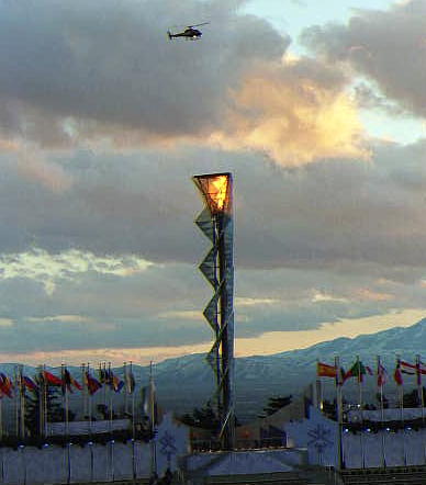
Corn was impressed with the necessarily high security measures taken before and throughout the Games. Security helicopters flew overhead. During training, Athlete Drivers were given multiple alternative routes for each planned journey, and drivers were told to not stop for any reason once the drive began. Outside all Games venues were security screening ports for pedestrians similar to those at airports. There were also checkpoints for all vehicles entering venues. Vehicles’ exteriors were always checked. These often included examination of gas tanks, engines, luggage compartments, and use of mirrors on long handles to examine the vans’ undercarriages. Some of the checks also required all van occupants to disembark for an extensive interior exam of the vehicle as well.
The security measures were effective. There was no news-breaking crisis.
Most of the athletes, even young ones, and their coaches had already spent much of their lives preparing for or attending Olympics games at their varied world-wide locations. All of those Corn and other drivers talked to unanimously said the Salt Lake 2002 Olympic Winter Games were by far the best of any Games they had attended.
The Salt Lake Organizing Committee told their Team 2002 volunteers when they had arrived for duty: “We hope this incredible experience will remain with you forever as we come together to light the fire within.”
The Team’s mission was “to be the Best Games Work Force Ever.” Mission accomplished.
He was an outstanding man who played a significant role in shaping the West: Captain Joseph C. Lea (1841–1904), “the Father of Roswell.” Lea was especially dominant in leading southeast New Mexico from a small speck on the frontiers of the cattleman and the farmer to one of the most advanced areas in New Mexico Territory. With the contributions of Lea and other developers, such as J.J. Hagerman and Charles Eddy, the Pecos Valley area became a leading region of New Mexico.
Lea started life as a farm boy in Tennessee and Missouri. His father, Dr. Pleasant Lea, was a well-to-do doctor and planter. When the Civil War broke out, J.C. and his brother, Frank, joined W.C. Quantrill’s Confederate guerrillas to defend their country against plundering by the Kansas Jayhawkers in the Missouri-Kansas border war. J.C. Lea was wounded in Quantrill’s raid on Lawrence, Kansas. Lea also served under CSA Gen. J.O.Shelby in the 6th Missouri Calvary, but for the last two years of the war, he was a captain commanding his own men in Louisiana opposite Vicksburg. Forever afterward, he was known as “Captain.”
Lea moved around the South after the war and in 1867, married a widow, Ellen Burbridge, who died four years later. Following another period of restlessness, Lea met and married Sallie Wildy in 1875. She was the beautiful daughter of W.W. Wildy, a Mississippi planter.
Lea soon departed for New Mexico Territory in search of something more interesting than cotton production. After a few years ranching sheep and cattle around Wheeler Peak in northern New Mexico, Lea moved his family and operations to the Roswell area. The Leas had two children: Wildy was born in 1877 and Ella in 1881. Sallie died in 1884, leaving J.C. with their two young children.
Van C. Smith had already started Roswell before the Leas arrived, but Lea was responsible for turning it into a growing and thriving community — thus earning the title “Father of Roswell.” Lea was a lot more than just the Father of Roswell, however. He kept the Lincoln County War out of Roswell and later was a major player in ridding the Territory of one “Billy the Kid.” Following the war, Lea started a large-scale ranching enterprise: The Lea Cattle Company. Financed primarily by New York businessman Horace Thurber, the Lea Cattle Co. by some estimates had the largest ranch with the most cattle of any ranch in Lincoln County and probably in the Territory by 1890. Lea bought 50 miles of waterfront land along the Rio Bonito and Rio Hondo, from Ft. Stanton to the Pecos River.
The cattle company was created mainly to raise cattle, but it also owned much land that was suitable for development as farms and town lots. To entice interested farmers to the Pecos Valley, the Lea Cattle Co. embarked on an effort to develop both the farmland of the Valley and the town of Roswell. A major project was the construction of several canals to water thousands of acres of farmland from the North Spring, Hondo and South Spring rivers. They also surveyed the original streets and several additions to Roswell and commenced selling lots to prospective settlers who wanted to go into business and build homes. Lea Cattle Co. began to falter about 1891, and the Panic of 1893 started the gradual but eventual collapse of the company.
In the meantime, J.C. Lea was the primary influence in the creation of Chaves and Eddy counties in 1889. He donated the courthouse square in Roswell but declined to have his home county named for him. The incorporation of Roswell in 1891, the building of the railroad into Roswell in 1894, and the establishment of numerous businesses in the 1800s and 1890s all felt Lea’s influence.
Goss Military Institute was established in Roswell in 1891, largely through the efforts of Lea and his third wife, Mabel. The school became New Mexico Military Institute in 1893, and is still one of the foremost military academies in the country.
Roswell’s government was reorganized from a town to a city in 1903. The Democrats drafted Lea to run for mayor, and he was elected to serve until the next regular election cycle. Regrettably, he lived only two months after his election, dying in February 1904 at the age of 62.
J.C. was honored and recognized for his accomplishments in his lifetime as well as after his death. Lea Avenue, Lea Hall, Lea Lake and Lea County attest to the high honor which New Mexico Territory bestowed upon this patriarch. Lea also experienced a lot of distress, losing his first two wives to early deaths, seeing his son confined to the Territorial mental hospital for life, and seeing the collapse of some of his major developments.
During his adult life, Lea was a guerrilla, a cattleman, a developer and a patriarch to one of New Mexico’s most vital regions. Captain Joseph C. Lea was a genuinely extraordinary man, much revered by everyone who came under his influence.